Terminal Island
Geographic communities
(318)
California
(1247)
Terminal Island
(249)
Related articles from the
Densho Encyclopedia :
Terminal Island, California
249 items
249 items
img
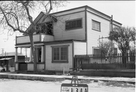
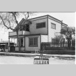
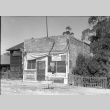
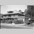
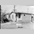
House labeled East San Pedro Tract 134A (ddr-csujad-43-121)
Photograph number 1383 of a two story house numbered 542 on Terminal Island. Sign reads: East San Pedro Tract 134A. Negative scan. See this object in the California State Universities Japanese American Digitization project site: ter_02_013
img
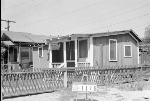
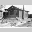
House labeled East San Pedro Tract 111B (ddr-csujad-43-149)
Photograph number 1494 of a house numbered 116 1/2 on Terminal Island. The sign near the fence reads: East San Pedro Tract 111B. Negative scan. See this object in the California State Universities Japanese American Digitization project site: ter_02_045
img
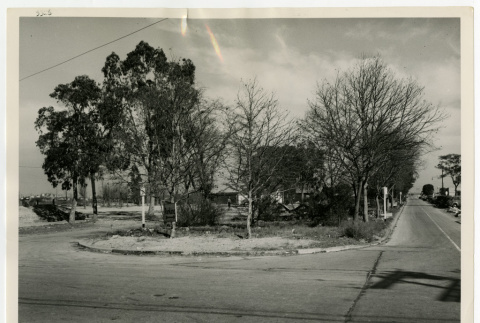
Terminal Way looking northeast (ddr-csujad-43-255)
Photograph number SP-5326 of Terminal Way. Note on the back side reads: Terminal Way in East San Pedro looking northeast. See this object in the California State Universities Japanese American Digitization project site: ter_04_059_001
img
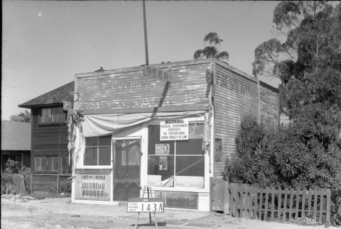
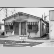
Storefront labeled East San Pedro Tract 143A (ddr-csujad-43-49)
Photograph number 1189 of a storefront on Terminal Island that has a federal government warning sign attached. The sign in front of the store reads: East San Pedro Tract 143A. Negative scan. See this object in the California State Universities Japanese American Digitization project site: ter_01_070
img
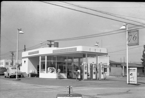
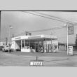
Union Oil Dealer gas station (ddr-csujad-43-130)
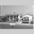
Photograph number 1394 of a Union Oil Dealer gas station on Terminal Island. Two cars are parked near the gas station. Sign reads: 244A1. Negative scan. See this object in the California State Universities Japanese American Digitization project site: ter_02_024
img
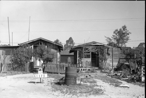
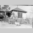
Houses labeled East San Pedro Tract A117B (ddr-csujad-43-80)
Photograph number 1224 of two houses on Terminal Island with another house or structure in the back. Sign reads: East San Pedro Tract A117B. Negative scan. See this object in the California State Universities Japanese American Digitization project site: ter_01_105
img
Houses on Scranton Walk (ddr-csujad-43-214)
Photograph of a row of houses on the corner of Ocean Avenue and Scranton [Walk] on Terminal Island. The sign on the grass reads: Plot no. [number] 6 29 42. See this object in the California State Universities Japanese American Digitization project site: ter_04_001
img
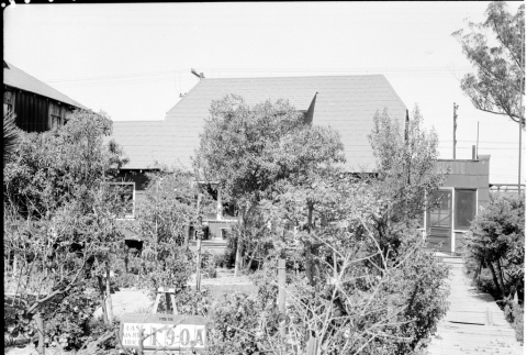
House labeled East San Pedro Tract 190A (ddr-csujad-43-153)
Photograph number 1499 of a house covered by trees on Terminal Island. The sign in the trees reads: East San Pedro Tract 190A. Negative scan. See this object in the California State Universities Japanese American Digitization project site: ter_02_049
img
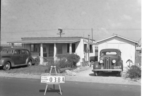
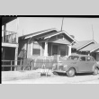
House labeled East San Pedro Tract 038A (ddr-csujad-43-128)
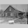
Photograph number 1392 of a house on Terminal Island with two parked cars near it. Sign reads: East San Pedro Tract 038A. Negative scan. See this object in the California State Universities Japanese American Digitization project site: ter_02_022
img
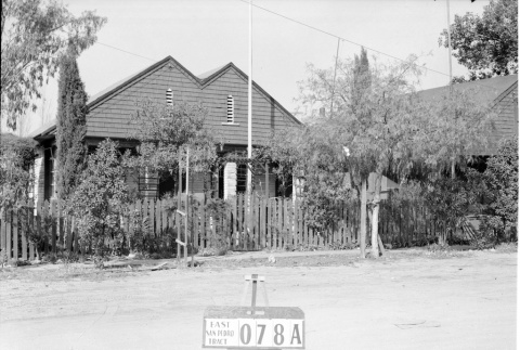
House labeled East San Pedro Tract 078A (ddr-csujad-43-141)
Photograph number 1486 of a house on Terminal Island. Sign reads: East San Pedro Tract 078A. Negative scan. See this object in the California State Universities Japanese American Digitization project site: ter_02_037
img
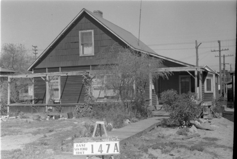
House labeled East San Pedro Tract 147A (ddr-csujad-43-28)
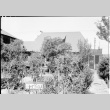
Photograph number 1166 of a house on Terminal Island with plants in front. Sign reads: East San Pedro Tract 147A. Negative scan. See this object in the California State Universities Japanese American Digitization project site: ter_01_049
img
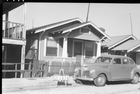
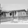
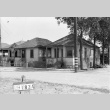
House labeled East San Pedro Tract 102A (ddr-csujad-43-54)
Photograph number 1194 of a house on Terminal Island with a car parked in front. Sign reads: East San Pedro Tract 102A. Negative scan. See this object in the California State Universities Japanese American Digitization project site: ter_01_075
img
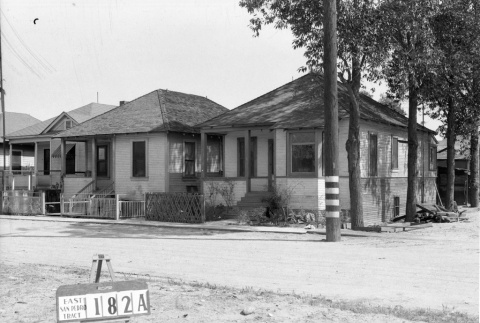
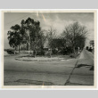
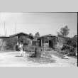
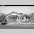
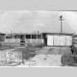
Houses labeled East San Pedro Tract 182A (ddr-csujad-43-101)
Photograph number 1285 of a three houses on Terminal Island. The sign across the street reads: East San Pedro Tract 182A. Negative scan. See this object in the California State Universities Japanese American Digitization project site: ter_01_132
img
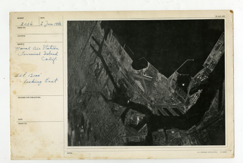
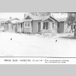
Naval Air Station looking east (ddr-csujad-43-265)
Photograph number 2006 of the Naval Air Station of Terminal Island. Subject reads: Naval Air Station Terminal Island Calif. [California] Alt. [Altitude] 12000' looking east. See this object in the California State Universities Japanese American Digitization project site: ter_05_003
img
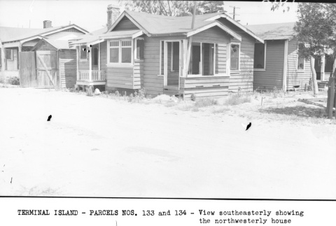
Terminal Island-Parcels nos. 133 and 134 (ddr-csujad-43-183)
Photograph number 2162 of houses on Terminal Island. Caption reads: Terminal Island -Parcels Nos. [numbers] 133 and 134 - View southeasterly showing the northwesterly house. Negative scan. Title from caption. See this object in the California State Universities Japanese American Digitization project site: ter_02_081
img
House labeled East San Pedro Tract 141A (ddr-csujad-43-43)
Photograph number 1183 of a two story house on Terminal Island. Sign reads: East San Pedro Tract 141A. Negative scan. See this object in the California State Universities Japanese American Digitization project site: ter_01_064
img
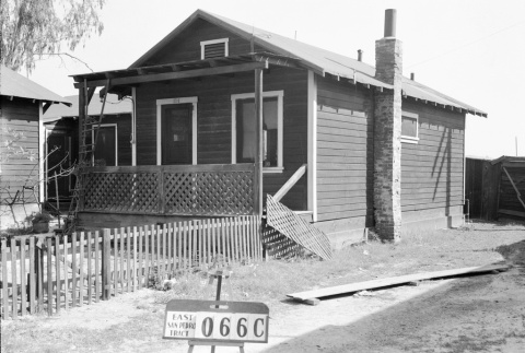
House labeled East San Pedro Tract 066C (ddr-csujad-43-161)
Photograph number 1507 of a house numbered 114 on Terminal Island. Sign reads: East San Pedro Tract 066C. Negative scan. See this object in the California State Universities Japanese American Digitization project site: ter_02_057
img
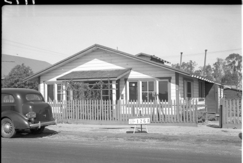
House labeled East San Pedro Tract 126A (ddr-csujad-43-34)
Photograph number 1173 of a house on Terminal Island with a car parked in front. Sign reads: East San Pedro Tract 126A. Negative scan. See this object in the California State Universities Japanese American Digitization project site: ter_01_055
img
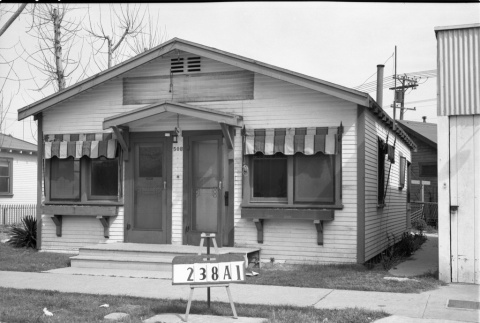
House labeled 238A1 (ddr-csujad-43-133)
Photograph number 1476 of a house numbered 508 on Terminal Island. Sign reads: 238A1. Negative scan. See this object in the California State Universities Japanese American Digitization project site: ter_02_027
img
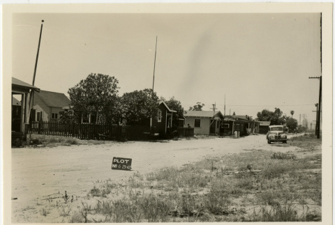
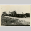
Street view of Terminal Island (ddr-csujad-43-219)
Photograph of a street on Terminal Island. A row of houses is pictured on the left, while a car is pictured one the right. Sign reads: Plot no. [number] 6 29 42. See this object in the California State Universities Japanese American Digitization project site: ter_04_010
img
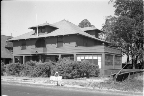
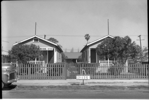
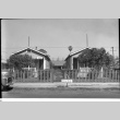
Patrol office and building labeled East San Pedro Tract 125 (ddr-csujad-43-51)
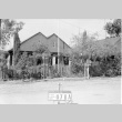
Photograph number 1191 of two buildings, one of which is a Patrol Office on Terminal Island. The sign in front of both buildings reads: East San Pedro Tract 125. Negative scan. See this object in the California State Universities Japanese American Digitization project site: ter_01_072
img
House labeled East San Pedro Tract 020A (ddr-csujad-43-166)
Photograph number 1513 of a house numbered 947 on Terminal Island. Attached to the fence is a federal government warning sign. The sign near the fence reads: East San Pedro Tract 020A. Negative scan. See this object in the California State Universities Japanese American Digitization project site: ter_02_063
img
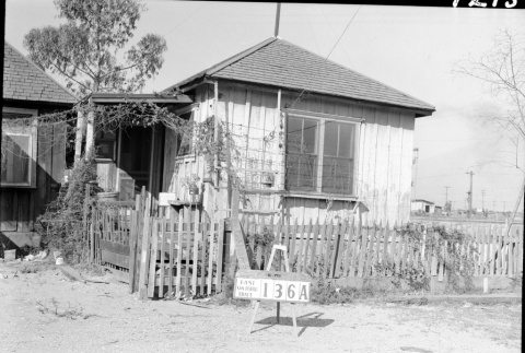
House labeled East San Pedro Tract 136A (ddr-csujad-43-72)
Photograph number 1215 of the side of a house on Terminal Island. The sign in front of the fence reads: East San Pedro Tract 136A. Negative scan. See this object in the California State Universities Japanese American Digitization project site: ter_01_096
img
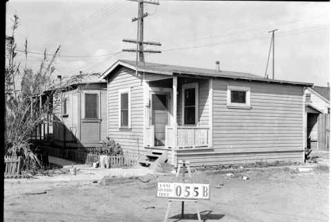
House labeled East San Pedro Tract 055B (ddr-csujad-43-178)
Photograph number 1526 of a house numbered 121 on Terminal Island. Sign reads: East San Pedro Tract 055b. Negative scan. See this object in the California State Universities Japanese American Digitization project site: ter_02_076
img
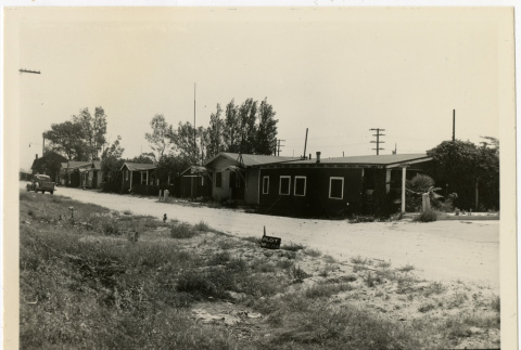
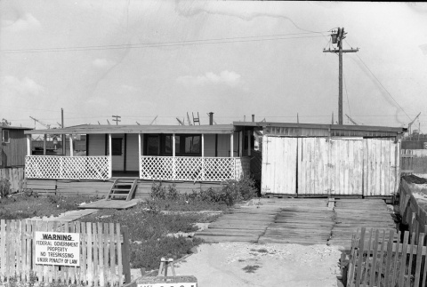
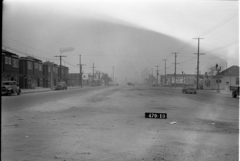
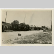
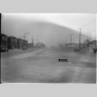
Street with houses and businesses (ddr-csujad-43-206)
Appraisal photograph number 2990 for the H.O.L.C [Home Owners' Loan Corporation] of possibly a street in San Pedro or Terminal Island. A barrage balloon is pictured floating above the buildings on the left side. Negative scan. See this object in the California State Universities Japanese American Digitization project site: ter_03_049