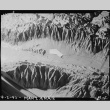
Relief map depicting camp location

PARTNER
Densho
Visit partner
OBJECT ID
ddr-densho-37-411 (Legacy UID: denshopd-i37-00411)
PARENT COLLECTION
National Archives and Records Administration Collection
DESCRIPTION
Original WRA caption: Manzanar Relocation Center, Manzanar, California. Picture of relief map showing location of Manzanar, War Relocation Authority Center for evacuees of Japanese ancestry, in Owens Valley, California, which is flanked in background by the High Sierras and in foreground by Mount Whitney, loftiest peak in the United States.
DATE
2-Apr-42
OBJECT GENRE
Photographs
OBJECT FORMAT
Still Image
TOPICS
FACILITY
CREATORS
- Albers, Clem (photographer)
PERSONS/ORGANIZATIONS
CONTRIBUTOR
Densho
PREFERRED CITATION
Courtesy of the National Archives and Records Administration
RIGHTS

This work is free of known copyright restrictions.
